
RBF絕版 RCSS chart 21 松山機場航圖 CHT-RCSS21 *free shipping* 全球免運費
RBF絕版 RCSS chart 21 松山機場航圖 CHT-RCSS21 *free shipping* 全球免運費
Couldn't load pickup availability
RBF In Stock RCSS Chart 21 Songshan Airport Aerial Chart CHT-RCSS21
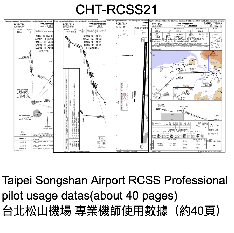
【Introduction】Limited Edition Collector's Edition! Professional pilot-used data aerial chart (approx. 40 pages), a must-have for aviation enthusiasts and flight simulator players. This product contains detailed arrival, departure, instrument landing, and ground aerial chart data for Taipei Songshan Airport (RCSS) used by professional pilots, with approximately 40 pages of complete content. Product Background: As a city airport of significant historical and geographical importance in Taiwan, Songshan Airport (RCSS) presents a significant challenge to every approach due to its airway design and surrounding terrain (such as Guanyin Mountain and the Dazhi Fortress Area). This chart accurately records key data including SID (Standard Instrument Departure), STAR (Standard Instrument Arrival), Approach Chart, and airport ground taxiway configuration. Whether used for aviation collecting, educational research, or as an essential reference for flight simulator enthusiasts tackling challenging approaches to Songshan Airport's Runways 10 or 28, this item possesses both practical and collectible value and is rarely seen on the market.
【Material】Paper
【Size】Length 29.7 cm x Width 21 cm
【Notes】Aeronautical chart data may differ from current airspace due to updates from the Civil Aeronautics Administration. Please do not use it for actual flight navigation. The item is of moderate size and supports convenience store pickup and mail order.
#We encourage you to communicate with us before placing your order to ensure a smooth and pleasant shopping experience.
#Our prices are already discounted, therefore we do not accept price negotiations; disrupting the shopping order will result in immediate blocking.
#Subjective perception or minor issues (such as "paint chipping, rashes, scratches, warping, box damage") are normal. Please do not place an order if you mind.
#We operate on a pre-order basis. For more information about us, please search RBF online.
#If you have special requirements or are extremely picky about the products, you are welcome to visit us in person.
#The text and images on this page are original content of RBF and are used for product description only.
You are welcome to refer to them, but please do not reproduce or use them without permission. Thank you for your understanding and respect.
Listing Time: 2026/06/02 14:37
#1-23-1
RBF 現貨 RCSS chart 21 松山機場航圖 CHT-RCSS21
【介紹】絕版限量珍藏!專業飛行員實際使用數據航圖(約40頁),航空迷與模擬飛行玩家必備。 本商品為專業飛行員實際使用的臺北松山機場(RCSS)詳細進出場、儀降及地面航圖數據,完整內容約 40 頁。 商品背景: 松山機場(RCSS)作為臺灣具備重要歷史與地理意義的市區機場,其航道設計與周邊地形(如觀音山、大直要塞區)讓每一次的進場都極具考驗。本航圖精準收錄了包括 SID(標準儀器離場)、STAR(標準儀器進場)、Approach Chart(進場航圖)以及機場地面滑行道配置等關鍵數據。 無論是作為航空珍藏、教學研究,或是模擬飛行(Flight Simulator)玩家挑戰松山機場 10 跑道或 28 跑道高難度進場的案頭必備參考,皆極具實用與收藏價值,市面少見。
【材質】紙
【尺寸】長度 29.7 cm x 寬度 21 cm
【備註】航圖數據可能隨時間與民航局更新而與現行真實空域有所出入,請勿用於實際飛行導航。 商品體積適中,支援超商取貨與郵寄。
#在您下單之前,我們鼓勵您積極與我們溝通,以確保您的購物體驗順利愉快。
#我們的價格已經優惠,故不接受議價的談判;擾亂購物秩序將直接封鎖。
#主觀認知或輕微問題(如「掉漆、起疹、刮傷、歪斜、盒損」)屬正常現象,介意者請勿下單。
#我們是預約制,有關我們的更多資訊,請上網搜尋 RBF。
#若您有特別要求或對商品極度挑剔,歡迎親自前來。
#本頁文字與圖片為 RBF 原創內容,僅供商品介紹使用。
歡迎參考,但請勿未經允許轉載或使用,感謝理解與尊重。
上架時間:2026/06/02 14:37
#1-23-1
Share
